Top

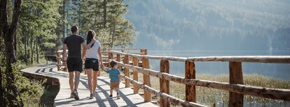
Circular nature path at the Lake

Antholz Valley
Add to favourites
Category
Difficulty
Easy
Duration
1:30
in hours
Distance
3.4
in km
Suggested period
Jan
Feb
Mar
Apr
May
Jun
Jul
Aug
Sep
Oct
Nov
Dec
NEW: MOVE calculates your personal route time for this tour.
Find out more about the project

Lake Antholz parking spot > passed the Huberalm Hut on to the Tiroler Hut > cross the stream and walk toward the lake > keep your left for the nature trail around the mountain lake. The walking tour can also be done the other way around.

Tags
  • Suitable for strollers
  • Accessibility
  • Family-friendly
Route data
Easy
Distance
3,4 km
Duration
1 h 30 min
Ascent
79 m
Decent
79 m
Physical condition
Scenary
Highest point
1.680 m
Lowest point
1.641 m
Suggestions

Especially in autumn the hike around Lake Antholz, with all the autumn colors, is beautiful !!!

How to get there

Arrival by public transport

from train station Valdaora:

  • by bus 431 to the bus stop Lago di Anterselva

>See here for the bus & train timetable

Antholz Valley
Lake Antholz
Lakes, cascades
Antholz Valley
Südtirol Arena Alto Adige - Biathlon stadium
Cross-country skiing centres
Antholz Valley
Huberalm
Open
closed
Restaurant
Antholz Valley
Tirolerhütte
Open
closed
Bar / Café / Bistro
Antholz Valley
Enzianhütte hut
Open
closed
Restaurant
You might be interested in
Discover related tours
Antholz Valley
Burgegga Mill
Distance 2,6 km
Duration 49 min
Ascent 136 m
Decent 136 m
Antholz Valley
Urig Trail
Distance 10,9 km
Duration 4 h 01 min
Ascent 1.050 m
Decent 1.050 m
Biotope Rasner Möser Oberrasen | © Notdufter Anna, Tourismusverein Antholzertal
Intermediate
Add to favourites
Antholz Valley
Niederrasen - Wasserwaldile - Oberrasen - Biotope Rsner Möser
Distance 8,9 km
Duration 2 h 22 min
Ascent 116 m
Decent 123 m
Panorama | © TV Antholzertal, Tourismusverein Antholzertal
Intermediate
Add to favourites
Antholz Valley
Panoramic walking tour: Niederrasen - Redensberg - Raut
Distance 9,7 km
Duration 3 h 00 min
Ascent 426 m
Decent 426 m
Antholz Valley
Hinterpasslerhütte - Staller Alm
Distance 2,6 km
Duration 45 min
Ascent 22 m
Decent 120 m
Bild | © © Plaickner Josef / Tourist Info Antholzertal, Olang
Intermediate
Add to favourites
Antholz Valley
Hike to the Hofstatt hut
Distance 1,3 km
Duration 40 min
Ascent 209 m
Decent 6 m